Weatherproof Witnesses: The Commercial SAR Layer That Is Making Clouds Less Useful
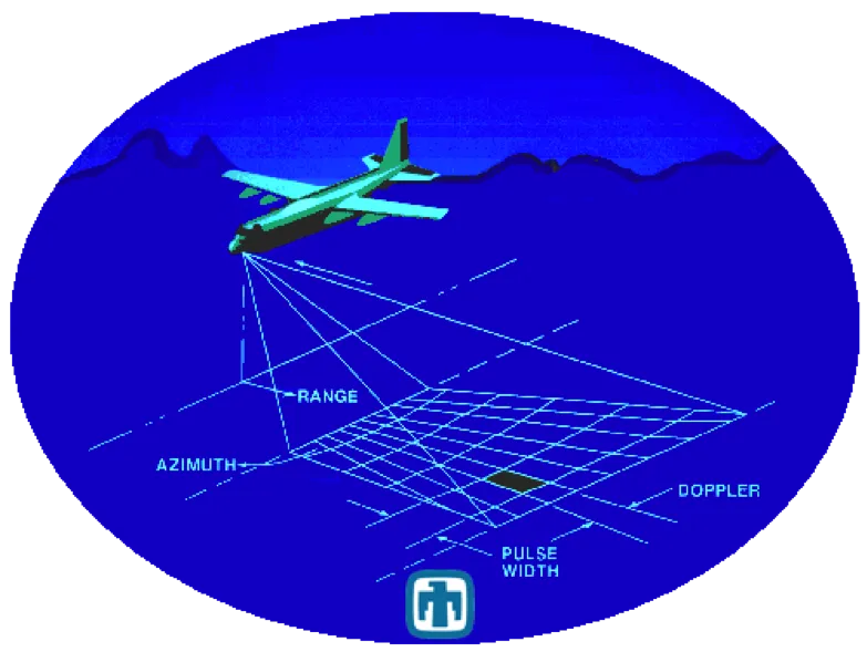
Photo: Wclxs11, CC BY-SA 3.0, via Wikimedia Commons
For most of the history of military aviation, the sky was an accomplice. Clouds, darkness, and adverse weather imposed a natural delay on observation. An aircraft could move under a solid overcast and, for practical purposes, disappear from the battlespace picture until conditions improved or someone got close enough to see it. Low observables added another layer to that bargain: reduce the radar return, shape the airframe, manage the emissions, and let the atmosphere do the rest. In 2026, that bargain is being quietly renegotiated from orbit.
The Old Bargain with the Sky
Synthetic-aperture radar is not new. The physics that let a moving radar platform synthesize a fine-resolution image from many pulses has been understood for decades, and space-based SAR has been part of the remote-sensing toolkit since the late 1970s. What is new is the commercial constellation. Instead of a handful of government satellites with long tasking cycles and tightly controlled archives, there are now multiple companies operating small SAR spacecraft in low Earth orbit, selling imagery, change detection, and analytics to anyone with a budget and a purpose. The result is not a single omniscient eye. It is a growing population of weather-independent sensors whose revisit rates, resolution, and data-access models are improving on commercial rather than procurement timelines.
That matters because concealment is not only about what a sensor can resolve. It is also about how often someone is looking. A stealth aircraft on a ramp under a shelter is a different problem from a stealth aircraft in transit. A base under construction is a different problem from a base in routine operation. Commercial SAR does not need to see the invisible aircraft to be useful. It can see the visible infrastructure around it, the patterns of activity that support it, and the changes that precede or follow its use.
What SAR Actually Reveals, and What It Does Not
It is important to be precise about the mechanism. SAR does not measure radar cross section in the way a fire-control radar does. It illuminates a scene with its own energy and forms an image from the returned echoes. That means it is sensitive to geometry, surface roughness, moisture, and the arrangement of objects. It can image through cloud and at night. It can detect structures, track construction, and, with sufficient resolution and favorable conditions, identify the outlines of aircraft, vehicles, and support equipment.
What it cannot do is magically reveal a low-observable airframe in flight at long range simply because the satellite carries a radar. The signature of a stealth aircraft is designed to reduce returns across specific bands and aspects; a space-based SAR operates under different geometry, power, and resolution constraints. The practical threat is more indirect and, in some ways, more corrosive. Commercial SAR is becoming a persistent monitoring layer for the places stealth aircraft depend on: runways, shelters, maintenance aprons, fuel farms, and the logistics chain that makes sorties possible. It also provides a cueing function. If a SAR constellation flags a change at a dispersal airfield, other sensors can be pointed at the same location. The weather no longer guarantees a delay in that cueing process.
The Constellation Effect
A single SAR satellite is a curiosity. A constellation is a habit. Commercial operators are fielding groups of small spacecraft with varying imaging modes, and the market is pushing toward higher revisit rates and faster data delivery. For a US audience accustomed to thinking of overhead imagery as a government monopoly, the shift is significant. The National Reconnaissance Office has moved to integrate commercial radar data into its architecture, and defense agencies are experimenting with commercial analytics for indications and warning. The precise contracts and program names matter less than the direction of travel: space-based radar is becoming a routine input to operational picture-building, not a special-access novelty.
This changes the cover story in a subtle way. During the Cold War and through the 1990s, weather was a reliable planning assumption for many air operations. If the forecast was bad, certain collection capabilities degraded. Commercial SAR does not eliminate that calculus, but it raises the baseline. An adversary or an observer with access to commercial SAR can now ask, every few hours, what changed at a given airfield, regardless of cloud cover. That is not the same as tracking a stealth aircraft in flight. It is something closer to tracking the conditions that make its employment visible.
AI and the Change-Detection Problem
The raw image is only part of the story. The real leverage comes from automated change detection. Commercial SAR providers and third-party analytics firms are building tools that compare repeated passes over the same area, flag new construction, identify vehicles or aircraft, and surface anomalies. Machine learning is well suited to this task because SAR imagery has consistent geometry and because the volume of data is growing faster than human analysts can review.
The limitations are real. Change detection produces false positives. Resolution is not unlimited. Tasking is not instantaneous, and commercial licensing can restrict who sees what and when. But the trend line is unfavorable for anyone relying on obscurity. Open-source analysts already use commercial SAR to monitor airfields, shipyards, and military build-ups. The same tools that expose a new hangar can expose a new dispersal pattern. For signature management, the implication is that physical concealment and operational pattern discipline matter more, not less. A low-observable aircraft is only as hidden as the infrastructure that supports it.
Why the Stealth Community Is Paying Attention
The US stealth community has traditionally treated signature reduction as a property of the vehicle. That framing is necessary but incomplete. Signature management is also a property of the operating environment: the basing posture, the maintenance footprint, the emissions discipline, and the deception plan. Commercial SAR does not defeat low observables. It compresses the time available for the environment to hide them.
That is why the conversation is shifting from novelty to architecture. The question is no longer whether commercial SAR can see a stealth aircraft. The question is how quickly a persistent, all-weather, commercially available monitoring layer can detect the changes around that aircraft and cue other sensors. The answer in 2026 is: faster than it could a decade ago, and likely faster still in the years ahead. The cloud cover that once bought hours may soon buy minutes.
A Signature-Management Response
The response is not to abandon low observables. It is to treat commercial SAR as one more layer in the detection stack and to plan accordingly. That means hardening the support chain against pattern analysis, using shelters and dispersal more deliberately, managing construction signatures, and assuming that any fixed facility is under repeated commercial observation. It also means understanding the difference between detection and identification. A SAR constellation may see that something changed without knowing exactly what it means. The advantage goes to the side that can fuse that cue with other data faster than the defender can adapt.
In that sense, commercial SAR is less a stealth-killer than a stealth-accountant. It keeps a persistent ledger of the visible world and makes it harder to hide the books. Low observables will remain essential, but the cover story is changing. Bad weather is no longer a reliable alibi.